Wednesday, July 21, 2010
Chal Nakhjir Cave
Chal Nakhjir is a rare geological phenomenon, discovered in 1989 and is located on the side of the road connecting Delijan to Naragh, Markazi province, Iran. The cave belongs to the Cenozoic period and has been formed as a result of tectonic factors and aerobic chemical reactions.
Love learning about our world? Discover online college classes.
Chal Nakhjir is known for its exceptional white dolomite sediments, covering the floor of major corridors of the cave. The speleothems are exceptional too, looking like white popcorn. Even regular stalactites and stalagmites have this pure white cover of calcite and aragonite crystals. The height of this cave in some places reaches over 20 m while having deep valleys in its divergent paths. A cave lake is located 140m inside the cave, 70m below the entrance.
The cave opened for public on March 2010.
Source
Tuesday, July 13, 2010
Marina Bay Sands
Marina Bay Sands is an integrated resort fronting Marina Bay in Singapore. Developed by Las Vegas Sands, it is billed as the world's most expensive standalone casino property at S$8 billion (US$5.7 billion), including cost of the prime land.
When complete, the resort will feature a 2,560-room hotel, a 120,000 sq.m. convention-exhibition center, The Shoppes mall, an Art-Science museum, two Sands Theatres, six "celebrity chef" restaurants, two floating pavilions, a casino with 500 tables and 1,600 slot machines. The complex is topped by a 340m-long SkyPark with a capacity of 3,900 people and a 150m infinity swimming pool, set on top of the world's largest public cantilevered platform, which overhangs the north tower by 67m. The 20-hectare resort was designed by Moshe Safdie Architects. The local architect of record was Aedas Singapore, and engineering was provided by Arup and Parsons Brinkerhoff (MEP)
Originally set to open in 2009, Las Vegas Sands faced delays caused by escalating costs of material and labour shortages from the onset. The severe global financial crisis also pressured the company to delay its projects elsewhere to complete the integrated resort. Although Marina Bay Sands has been compared on scale and development costs to MGM's CityCenter, the latter is a mixed-use development, with condominium properties - comprising three of the seven main structures, being sold off.
The resort was officially opened with a two-day celebration on 23 June 2010 at 3.18 pm, after a partial opening earlier in April. The museum, theatres and floating pavilions are still being built and are expected to be fully completed by December 2010.
Source
Thursday, June 24, 2010
The Crazy House
Hang Nga guesthouse, popularly known as The Crazy House, is an unconventional hotel building constructed from a project by Hang Viet Nga in Da Lat, Vietnam. The building conveys a distinctive fairy-tale-like mood, and comprises complex, organic, non-rectilinear shapes, much in the spirit of Gaudi and Hundertwasser.
Wednesday, June 16, 2010
The Underground Waterfall
Ruby Falls is a 145-foot high underground waterfall located within Lookout Mountain, near Rock City and Chattanooga, Tennessee in the United States. The cave which houses Ruby Falls was formed with the formation of Lookout Mountain. About 200 to 240 million years ago (in the Carboniferous period, at the end of the Paleozoic era) the eastern Tennessee area was covered with a shallow sea, the sediments of which eventually formed limestone rock. About 200 million years ago, this area was uplifted and subsequent erosion has created the current topography. The limestone in which the cave is formed is still relatively horizontal, just as it was deposited when it was below sea level. The Lookout Mountain Caverns, which includes Ruby Falls Cave, is a limestone cave. These caves occur when slightly acidic groundwater enters subterranean streams and eats away at the relatively soluble limestone, causing narrow cracks to widen into passages and caves in a process called chemical weathering. The stream which makes up the Falls entered the cave sometime after its formation.
Ruby Falls Cave features many of the more well-known types of cave formations (or speleothems) including stalactites and stalagmites, columns, drapery, and flowstone. The Falls are located at the end of the main passage of Ruby Falls Cave, in a large vertical shaft. The stream, 1120 feet underground, is fed both by rainwater and natural springs. It collects in a pool in the cave floor and then continues through the mountain until finally joining the Tennessee River at the base of Lookout Mountain. While Ruby Falls Cave combines with Lookout Mountain Cave to form the Lookout Mountain Caverns, the two caves were not actually connected by any passage. Ruby Falls Cave is the upper of the two and contains a variety of geological formations and curiosities which Lookout Mountain Cave does not have.
Source
Wednesday, June 9, 2010
The 2010 FIFA World Cup Venues
Soccer City Stadium, Johannesburg A football-specific stadium, Soccer City is currently the largest stadium in Africa with a capacity of 94,700. Most of the largest football events in South Africa are played at Soccer City and the venue is better suited to these events than the Ellis Park Stadium, where the final for the Rugby World Cup in 1995 was held. Soweto and the National Exhibition Centre in Nasrec are nearby.
Moses Mabhida Stadium, Durban is a stadium in Durban, South Africa, named after Moses Mabhida, a former General Secretary of the South African Communist Party. It is intended to be a world-class multi-use stadium. It will be one of the host stadiums for the 2010 FIFA World Cup. The stadium has a planned capacity of 70,000 during the World Cup and 54,000 afterwards. The stadium is adjacent to the Kings Park Stadium, in the Kings Park Sporting Precinct, and the Durban street circuit used for the A1GP World Cup of Motorsport.
Royal Bafokeng Stadium, Rustenburg is a rugby union, association football and athletics stadium in Phokeng near Rustenburg, South Africa. It was built and is managed by the Royal Bafokeng Nation. It is used as the home stadium for Premier Soccer League club Platinum Stars. The capacity of the stadium was increased from 38,000 to 44,530 to be able to host five first round matches and one second round match at the 2010 FIFA World Cup. The Royal Bafokeng Stadium plays host to the round one Group C match between England and the United States on 12 June, 2010.
Peter Mokaba Stadium, Polokwane is a football stadium in Polokwane (formerly Pietersburg), South Africa, that will be used for the 2010 FIFA World Cup. When completed in 2010 it will have a capacity of 46,000. It was named after Peter Mokaba, a former leader of the ANC Youth League. It is located 5 kilometers from the city centre and is located just east of the existing Pietersburg Stadium. The stadium is one of five new stadiums that will be built for the 2010 FIFA World Cup. Initial plans to upgrade the current Peter Mokaba Stadium were abandoned in favour of the R1,245,000,000 (ZAR) new Peter Mokaba stadium.
Free State Stadium, Bloemfontein is a stadium in Bloemfontein, South Africa, used for rugby union, as well as football (soccer). It was originally built in 1995 for that year's Rugby World Cup.
Mbombela Stadium, Nelspruits a newly built all seater 43,500-seat stadium and is one of the ten venues for the FIFA World Cup 2010. It is located on open land six kilometers west of Nelspruit, South Africa, with the stadium as the centrepiece of a proposed wider sports precinct with athletics and cricket as well as other sporting codes. The R1,050-million sports facility was ready for use well ahead of the June 2010 World Cup kickoff and has been made possible through taxpayer funding.
Loftus Versfeld Stadium, Pretoria is a sports stadium situated in Pretoria, South Africa. The stadium has a capacity of 51,762 and is an all seater venue. Recently hosted the 2009 Currie Cup final.
Ellis Park Stadium, Johannesburg is a rugby union and association football stadium in the city of Johannesburg, Gauteng Province, South Africa. It hosted the final of the 1995 Rugby World Cup, which was won by the country's national team, the Springboks. The large stadium was the country's most modern when it was upgraded in 1982 to accommodate almost 60,000 people. Today, the stadium hosts both football and rugby.
Nelson Mandela Bay Stadium, Port Elizabeth is a 48,000-seater stadium in Port Elizabeth. The five-tier, R2 billion (approximately US$270million) Nelson Mandela Bay Stadium was built overlooking the North End Lake, at the heart of the city. It is one of three coastal stadiums built in anticipation of the 2010 FIFA World Cup. It regularly hosts large scale football and rugby matches. The stadium has also been used as a concert venue.
Green Point Stadium, Cape Town is a newly built stadium for the 2010 FIFA World Cup. During the planning stage it was known as the Green Point Stadium, which was the name of the previous stadium on the site. The stadium is located in Green Point, between Signal Hill and the Atlantic Ocean, close to the Cape Town city center and to the Victoria & Alfred Waterfront, a popular tourist and shopping venue. The stadium has a capacity of 69,070. The stadium is connected to the waterfront by a new road connection, Granger Bay Boulevard, and is surrounded by a 60 hectare urban park.
Source
Thursday, June 3, 2010
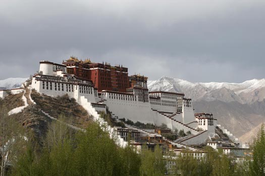
Potala Palace
The Potala Palace is located in Lhasa, Tibet Autonomous Region, China. It was named after Mount Potala, the abode of Chenresig or Avalokitesvara. The Potala Palace was the chief residence of the Dalai Lama until the 14th Dalai Lama fled to Dharamsala, India, after an invasion and failed uprising in 1959. Today the Potala Palace has been converted into a museum by the Chinese government.
The building measures 400 metres east-west and 350 metres north-south, with sloping stone walls averaging 3 m. thick, and 5 m. (more than 16 ft) thick at the base, and with copper poured into the foundations to help proof it against earthquakes. Thirteen stories of buildings – containing over 1,000 rooms, 10,000 shrines and about 200,000 statues – soar 117 metres (384 ft) on top of Marpo Ri, the "Red Hill", rising more than 300 m (about 1,000 ft) in total above the valley floor. Before the first skyscrapers were built, the Potala Palace was the world's tallest building.
Tradition has it that the three main hills of Lhasa represent the "Three Protectors of Tibet." Chokpori, just to the south of the Potala, is the soul-mountain (bla-ri) of Vajrapani, Pongwari that of Manjushri, and Marpori, the hill on which the Potala stands, represents Chenresig or Avalokiteshvara.
Source
Tuesday, May 25, 2010
Yunak Evleri Hotel In Turkey
Yunak Evleri is a well known hotel in Cappadocia, Turkey. It is a combination of six cave houses with a total of 27 private cave rooms dating back to the 5th and 6th centuries and crowned with a 19th century Greek Mansion. Yunak Evleri is an inspiring hotel - an ideal base for exploring Cappadocia's elaborate underground cities, hidden cavernous churches and enchanting rock terrain.
The name of the neighbourhood "YUNAK" comes from the old days when women used to do all their washing and of course, socialising by the fountain located at the village square. Being by the fountain and at the Yunak was the center of daily life.
These exceptional cave houses are renovated and decorated with care and in their own distinct style with strictly respecting the local character. The decor is elegant and personalized with beautiful hand-crafted furnishings and antiques. With 27 rooms, Yunak Evleri is small enough to be intimate, yet large enough to offer you privacy.
Monday, May 10, 2010
Mont Saint-Michel
Mont Saint-Michel is a rocky tidal island and a commune in Normandy, France (Le Mont-Saint-Michel). Its pyramid-like outline has become famous the world over and thousands of tourist flock each year for a Mont St. Michel tour. It is located approximately one kilometer (just over a half-mile) off the country's north coast, at the mouth of the Couesnon River near Avranches. The population of the island is 41. The mount is best known for the medieval Benedictine Abbey and steepled church that occupies most of the 1km-diameter clump of rocks jutting out of the waters of the English Channel. At high tide, Mont St Michel is almost entirely separated from the mainland. Only a narrow causeway, constructed in the 1880s preserves a link to the coast. (A bridge to replace the causeway and allow the circulation of tidal waters in the bay is scheduled for completion in 2012.) Beware: the tide comes in quickly (as swiftly as a galloping horse), as Victor Hugo claimed many tourists have drowned attempting to cross the sandy bay.
Source
Tuesday, April 20, 2010
Pink Lake
Lake Retba or Lac Rose lies north of the Cap Vert peninsula of Senegal, north east of Dakar. It is so named for its pink waters, caused by cyanobacteria in the water. The color is particularly visible during the dry season. The lake is also known for its high salt content, which, like that of the Dead Sea, allows people to float easily. The lake also has a small salt collecting industry and is often the finishing point of the Dakar Rally.
Many salt collectors work 6-7 hours a day in the lake, which has a salt content close to 40%. In order to protect their skin, they rub their skin with "Beurre de Karité" (shea butter, produced from shea nuts obtained from the Shea nut tree), which is an emollient used to avoid tissue damage. This lake was used on a task of the Amazing Race 6 in which teams had to collect salt in a basket from the bottom of the lake floor.
Source
Thursday, April 8, 2010
Boulders Beach
Boulders Beach is a sheltered beach made up of inlets between granite boulders, from which the name originated. It is located in the Cape Peninsula, near Simon's Town towards Cape Point, near Cape Town in the Western Cape province of South Africa. It is also commonly known as Boulders Bay.
It is a popular tourist stop because of a colony of African Penguins which settled there in 1982. Boulders Beach forms part of the Table Mountain National Park. The most popular recreational spot is Boulders Beach, but the penguins are best viewed from Foxy Beach, where newly-constructed boardwalks take visitors to within a few meters of the birds. It is also a popular swimming beach, although humans are restricted to beaches adjacent to the penguin colony.
Source
Wednesday, March 31, 2010
Tsingy de Bemaraha National Park
The Tsingy de Bemaraha National Park is a national park located in the African nation of Madagascar. The national park centers on two geological formations, the Great Tsingy and the Little Tsingy. Together with the adjacent Tsingy de Bemaraha Strict Nature Reserve, the National Park is a UNESCO World Heritage Site. The word tsingy is indigenous to the Malagasy language as a description of the karst badlands of Madagascar. The word can be translated into English as where one cannot walk barefoot.
The Tsingys are karstic plateaus in which groundwater has undercut the elevated uplands, and has gouged caverns and fissures into the limestone. Because of local conditions, the erosion is patterned vertically as well as horizontally. In several regions on western Madgascar, centering on this National Park and adjacent Nature Reserve, the superposition of vertical and horizontal erosion patterns has created dramatic "forests" of limestone needles.
The unusual geomorphology of the Tsingy de Bemaraha World Heritage Site, which encompasses both the National Park and the adjacent Strict Nature Reserve, means that the Site is home to an exceptionally large number of endemic species of plants and animals that are found only within extremely small niches within the tsingys. For example, the summit, slope, and base of a tsingy's limestone needle form different ecosystems with different species clinging to their exceptionally steep slopes.
Source
Thursday, March 25, 2010
Huacachina Village
Huacachina is a village in the Ica Region, in southwestern Peru. It is located in the Ica Province, near the city of Ica in the Ica District. Huacachina has a population of 115 (1999). The oasis features on the back of the 50 Nuevo Sol note.
Huacachina is built around a small natural lake in the desert. Called the "oasis of America," it serves as a resort for local families from the nearby city of Ica, and increasingly as an attraction for tourists drawn by the sports of sandboarding and taking dune buggy rides on sand dunes that stretch several hundred feet high.
Legend holds that the lagoon was created when a beautiful native princess was apprehended at her bath by a young hunter. She fled, leaving the pool of water she had been bathing in to become the lagoon. The folds of her mantle, streaming behind her as she ran, became the surrounding sand dunes. And the woman herself is rumored to still live in the oasis as a mermaid.
Currently, private landowners near the oasis have installed wells, in order to access the groundwater. This has had the effect of drastically reducing the level of water in the oasis. To compensate for this water loss, and preserve the oasis as an aesthetically pleasing destination for tourists, the city began a process of artificially pumping water into the oasis.
The area is popular for both dune buggying and sandboarding; exhilarating and unusual sports which are popular with visitors and locals alike. However, injuries are not uncommon, and several people have been killed in recent years sand boarding into the buildings surrounding the oasis. Sadly the dunes around the town have been overtaken by crime. Many tourists have been mugged in broad daylight. It is not recommended that tourists climb the dunes alone or at night.
Thursday, March 18, 2010
Basilica Cistern
The Basilica Cistern, also known as the "Sunken Palace" or "Yerebatan sarayi", is the largest of several hundred ancient cisterns that lie beneath the city of Istanbul (formerly Constantinople), Turkey. The cistern, located 500 feet (150 m) west of the Hagia Sophia on the historical peninsula of Sarayburnu, was built in the 6th century during the reign of Byzantine Emperor Justinian I. It was constructed to supply water to the Byzantine Palace primarily.
Basilica cistern is a very authentic place and a must see in Istanbul. It is open every day from 09:00 hrs to 18:30 and the entrance fee is 10 YTL (~7 USD) for foreign visitors.
Walk to the back of the Basilica Cistern, and you will find one upside down Medusa head supporting one of the columns. Why it is upside down has been a question of much discussion, but the best guess is that the people who placed the stone believed that if the head was upside down, it would ward off evil spirits. Not far from the upside-down Medusa head is a second Medusa head, which is sideways. Why one head is upside down and the other is sideways only deepens the question about their orientation.
Source
Wednesday, March 3, 2010
World's Largest Underwater Art Museum
Creator of the world's first underwater sculpture park, Jason de Caires Taylor has gained international recognition for his unique work. His sculptures highlight ecological processes whilst exploring the intricate relationships between modern art and the environment. By using sculptures to create artificial reefs, the artist’s interventions promote hope and recovery, and underline our need to understand and protect the natural world. The sculptures are sited in clear shallow waters to afford easy access by divers, snorkellers and those in glass-bottomed boats. Viewers are invited to discover the beauty of our underwater planet and to appreciate the processes of reef evolution.
Saturday, February 27, 2010
Table Mountain
Table Mountain is a flat-topped mountain forming a prominent landmark overlooking the city of Cape Town in South Africa, and is featured in the flag of Cape Town and other local government insignia. It is a significant tourist attraction, with many visitors using the cableway or hiking to the top. The mountain forms part of the Table Mountain National Park. The Table Mountain Cableway takes passengers from the lower cable station on Tafelberg Road, about 302 m above sea level, to the plateau at the top of the mountain. The upper cable station offers views overlooking Cape Town, Table Bay and Robben Island to the north, and the Atlantic seaboard to the west and south.
Hiking on Table Mountain is popular amongst locals and tourists, and a number of trails of varying difficulty are available. Because of the steep cliffs around the summit, direct ascents from the city side are limited. Platteklip Gorge, a prominent gorge up the centre of the main table, is a popular and straightforward direct ascent to the summit. Par for the course is about 2.5 hours but is done between 1–3 hours depending on one's fitness level.Rock climbing on Table Mountain is a very popular pastime. There are well-documented climbing routes of varying degrees of difficulty up the many faces of the mountain. The main climbs are located on cliffs below the upper cable station. No bolting can be done here and only traditional climbing is allowed. Commercial groups also offer abseiling from the upper cable station.
Most of the world's important caves occur in limestone but Table Mountain is unusual in having several large cave systems that have developed in sandstone. The biggest systems are the Wynberg Caves, located on the Back Table, not far from the Jeep Track, in ridges overlooking Orange Kloof and Hout Bay.
Source
Tuesday, February 9, 2010
One of the Most Beautiful Waterfalls - Iguazu Falls
Iguazu Falls are waterfalls of the Iguazu River located on the border of the Brazilian state of ParanĂ¡ and the Argentine province of Misiones. The falls divide the river into the upper and lower Iguazu.
The waterfall system consists of 275 falls along 2.7 kilometers (1.67 miles) of the Iguazu River. Position is at latitude (DMS): 25° 40' 60 S, longitude (DMS): 54° 25' 60 W . Some of the individual falls are up to 82 meters (269 ft) in height, though the majority are about 64 metres (210 ft). The Devil's Throat (Garganta del Diablo in Spanish or Garganta do Diabo in Portuguese), a U-shaped, 82-meter-high, 150-meter-wide and 700-meter-long (490 by 2300 feet) cataract, is the most impressive of all, and marks the border between Argentina and Brazil. Two thirds of the falls are within Argentine territory. About 900 meters of the 2.7-kilometer length does not have water flowing over it. The edge of the basalt cap recedes only 3 mm (0.1 in) per year. The water of the lower Iguazu collects in a canyon that drains into the ParanĂ¡ River at Argentina, shortly downstream from the Itaipu dam.


.jpg)
.jpg)
.jpg)
.jpg)
.jpg)